
The Super Typhoon Sinlaku has received much international recognition, being considered one of the strongest tropical weather patterns to occur recently. The typhoon is remarkable for its quick formation on a favourable basis, which made it grow very rapidly and develop into a super typhoon. Being characterised by strong winds, heavy rainfall, and numerous negative consequences that are caused by these factors, Sinlaku has turned into an extremely valuable subject of scientific research for many meteorologists and climate scientists around the world.
What is Super Typhoon Sinlaku and what causes its rise
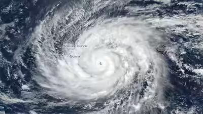
This particular super typhoon experienced what meteorologists refer to as “rapid intensification.” According to the American Meteorological Society, the rapid intensification (RI) of TCs does not have a universal definition but is customarily defined as a 1- or 10-min VMAX increase of around 30 kt (1 kt ≈ 0.51 m s−1) over 24 h. It is described as an event where the winds of the storm suddenly accelerate. defines rapid intensification as follows:Rapid intensification takes place only when all environmental factors conspire together in just the right fashion. As highlighted by the National Oceanic and Atmospheric Administration (NOAA),“Warm ocean waters can provide fuel for the tropical cyclone and help it intensify quickly if atmospheric conditions are favourable.”Sinlaku went through this same process. Warm ocean waters of more than 28°C allowed the typhoon to develop and evolve into a super typhoon. Satellite images show a clearly defined eye surrounded by cloud formations and thunderstorms.
Impact, risks, and preparedness measures
The Joint Typhoon Warning Centre (JTWC) issued a warning, wherein NASA released a VIIRS (Visible Infrared Imaging Radiometer Suite) captured image on the Suomi NPP satellite.Damage from Super Typhoon Sinlaku is not just limited to high winds. Floods and landslides may result from heavy rainfalls, especially in mountainous and coastal locations. The risk of storm surges is also very great and may cause damage, usually in low-lying areas.Preparedness plays a huge role in ensuring safety from any damage that may arise from natural disasters. People are often advised by their respective governments to:
- Evacuate dangerous coastal areas
- Strengthen buildings and infrastructures
- Prepare necessary provisions
The World Meteorological Organization (WMO) highlights the importance of Early Warning Systems: “Timely forecasts and warnings are vital for saving lives and minimising economic impacts of tropical cyclones.” Super Typhoon Sinlaku has highlighted the necessity of effective and timely forecasts.
Climate change and the future of Super Typhoons
Furthermore, Super Typhoon Sinlaku poses some significant issues regarding the impact of climate change on the strength of such storms. According to the study conducted by the Department of Atmospheric Sciences, University of North Dakota, ‘Tropical cyclones and climate change’, the frequency of tropical cyclones will remain almost the same, but their intensity will increase considerably. “As the world warms up, the number of intense tropical cyclones will increase in the coming years,” they said.A warmer ocean and changing atmosphere provide favourable conditions under which storms similar to Sinlaku gain more strength quickly and achieve higher intensities.In conclusion, Super Typhoon Sinlaku is not only a powerful storm but also evidence of the increasing strength of nature due to the changing climate conditions. Further studies of these phenomena will provide us with additional information and help us better cope with them in the future.